- [01] Adams Co, OH (18)
- [02] Allen Co, OH (2)
- [03] Ashland Co, OH (14)
- [04] Ashtabula Co, OH (11)
- [05] Athens Co, OH (20)
- [06] Auglaize Co, OH (5)
- [07] Belmont Co, OH (24)
- [08] Brown Co, OH (32)
- [09] Butler Co, OH (8)
- [10] Carroll Co, OH (22)
- [11] Champaign Co, OH (9)
- [12] Clark Co, OH (3)
- [13] Clermont Co, OH (10)
- [14] Clinton Co, OH (4)
- [15] Columbiana Co, OH (19)
- [16] Coshocton Co, OH (14)
- [17] Crawford Co, OH (13)
- [18] Cuyahoga Co, OH (15)
- [19] Darke Co, OH (8)
- [20] Defiance Co, OH (7)
- [21] Delaware Co, OH (10)
- [22] Erie Co, OH (4)
- [23] Fairfield Co, OH (9)
- [24] Fayette Co, OH (3)
- [25] Franklin Co, OH (12)
- [26] Fulton Co, OH (4)
- [27] Gallia Co, OH (9)
- [28] Geauga Co, OH (10)
- [29] Greene Co, OH (1)
- [30] Guernsey Co, OH (34)
- [31] Hamilton Co, OH (6)
- [32] Hancock Co, OH (5)
- [33] Hardin Co, OH (5)
- [34] Harrison Co, OH (15)
- [35] Henry Co, OH (4)
- [36] Highland Co, OH (15)
- [37] Hocking Co, OH (7)
- [38] Holmes Co, OH (12)
- [39] Huron Co, OH (15)
- [40] Jackson Co, OH (8)
- [41] Jefferson Co, OH (11)
- [42] Knox Co, OH (13)
- [43] Lake Co, OH (2)
- [44] Lawrence Co, OH (9)
- [45] Licking Co, OH (17)
- [46] Logan Co, OH (5)
- [47] Lorain Co, OH (13)
- [48] Lucas Co, OH (5)
- [49] Madison Co, OH (6)
- [50] Mahoning Co, OH (13)
- [51] Marion Co, OH (5)
- [52] Medina Co, OH (9)
- [53] Meigs Co, OH (15)
- [54] Mercer Co, OH (3)
- [55] Miami Co, OH (4)
- [56] Monroe Co, OH (28)
- [57] Montgomery Co, OH (11)
- [58] Morgan Co, OH (20)
- [59] Morrow Co, OH (9)
- [60] Muskingum Co, OH (24)
- [61] Noble Co, OH (15)
- [62] Ottawa Co, OH (8)
- [63] Paulding Co, OH (6)
- [64] Perry Co, OH (8)
- [65] Pickaway Co, OH (7)
- [66] Pike Co, OH (9)
- [67] Portage Co, OH (8)
- [68] Preble Co, OH (9)
- [69] Putnam Co, OH (9)
- [70] Richland Co, OH (11)
- [71] Ross Co, OH (7)
- [72] Sandusky Co, OH (8)
- [73] Scioto Co, OH (16)
- [74] Seneca Co, OH (16)
- [75] Shelby Co, OH (5)
- [76] Stark Co, OH (16)
- [77] Summit Co, OH (5)
- [78] Trumbull Co, OH (3)
- [79] Tuscarawas Co, OH (15)
- [80] Union Co, OH (9)
- [81] Van Wert Co, OH (5)
- [82] Vinton Co, OH (9)
- [83] Warren Co, OH (3)
- [84] Washington Co, OH (34)
- [85] Wayne Co, OH (20)
- [86] Williams Co, OH (4)
- [87] Wood Co, OH (5)
- [88] Wyandot Co, OH (10)
*GONE* (faded away and painted over)US Rt. 22(Cincinnati Zanesville Rd. SW) east of OH Rt. 674(Winchester Southern Rd.) by about 1.7 miles. The barn is on the right side of the highway headed northeast. Two signs. The MP/MC sign faced northeast. The MP sign faced southwest. Two ends. Black Background.
*GONE* (razed and removed) Along the north side of W. Akron - Canfield Rd./US Rt. 224, west of OH Rt. 45, in Ellsworth, by 2.7 miles. The barn was on the right side of the road headed west from Ellsworth. Two ends & One side. Mail Pouch sign on the west end. Melo-Crown Stogies on the east end (Previous to the Melo-Crown sign a Mail Pouch sign was on the east end). Mail Pouch sign on the south side. Black backgrounds.
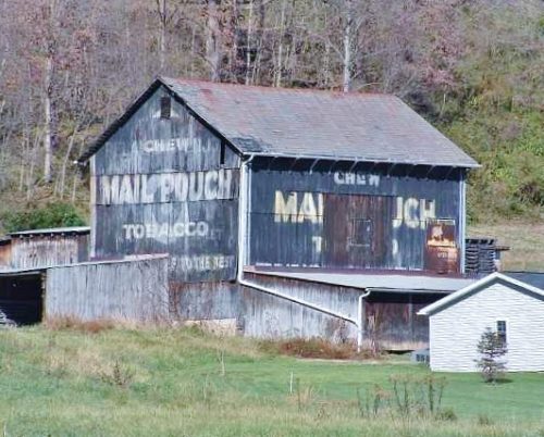
Along the northwest side of OH-78 northeast of the Main St. intersection, in McConnelsville, by 6.0 miles. The barn is on the left side of the highway headed northeast. There is a very faded Mail Pouch sign on the northeast side. The Mail Pouch (and earlier Melo Crown) signs on the southeast end have faded away. Black Backgrounds.
*GONE* (fallen & removed) Along the south side of Tallmadge Rd. (CR-18) west of OH-225, in Palmyra, by 2.3 miles. The barn was on the left side of the road headed west from Plamyra. The Mail Pouch sign faced east. One end. Black Background. The Melo-Crown sign was barely visible.
*GONE* (fallen) Along the northeast side of OH-125 northwest of US-52, in Friendship, by 3.2 miles. Two ends. There was a Mail Pouch sign with very faint Melo Crown sign on the southeast end of the barn; and, a Mail Pouch sign on the northwest end of the barn. Black Backgrounds.
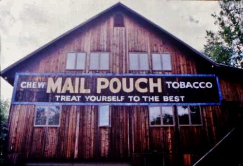
OH Rt. 128 (Hamilton Cleves Pike Rd.) west of I-74/I-275/US Rt. 52 by about 2.5 miles. Take exit 7 to OH Rt. 128 (Hamilton Cleves Pike Rd.) and head west. The barn is on the right side of the road headed west. Two ends. One side. Black.
OH Rt. 26, south of OH Rt. 800 by about 1.4 miles. The barn is on the right side of the highway headed south. Two ends and one side. Black.
OH Rt. 171 (Waynesburg Rd. NW) southeast of the Main St. intersection, in Waynesburg by about 4.9 miles; and, east of the Stark County line by about 4.0 miles. The barn is on the right side of the highway headed southeast. The signage faces northwest. One end. Red backgound.
US-40, east of OH-668 by about 6.8 miles. On the left side of the highway headed east from OH-668. The Mail Pouch/Red Man sign faces south. One end. Mail Pouch - Black background. Red Man - Yellow background.
US Rt. 52 (Ohio River Scenic Byway), southwest of the Scioto Co. line by about 1.0 mile. The barn is on the left side of the highway headed southwest from Scioto Co. line. Two ends. Black background.
Old US Rt. 33 (Pomeroy Rd.) south of US Rt. 50 by about 8.7 miles. Head south on Old US Rt. 33 to Rankin Rd. Turn right onto Rankin Rd. The barn is on the left side of Rankin Rd. about 500' from old US Rt,. 33. The MP sign faces east. One end. Black.
*GONE* (razed and removed) US Rt. 62 south of OH Rt. 32 by about 0.4 mile. Address is 11791 Hwy. 62, Macon. The barn was on the right side of the highway headed south. The MP/WOW signage faced north. One side. Original black background.
*GONE*(fallen) Along the east side of OH Rt. 41 south of Water St. (OH124), in Sinking Spring, by 0.4 mile. The barn was just north of the Adams Co. line. The barn was on the right side of the highway headed north from Adams County. The MPB/WOW sign faced north. One side. Black Background.
OH Rt. 800, southeast of OH Rt. 145, in Malaga, by about 0.3 mile. The barn is on the right side of the highway headed southeast. Two ends and One side. Black.
OH Rt. 821 (Cambridge Rd.), north of I-77, exit 6, by about 2.3 miles. The barn is on the left side of the highway headed northeast. One end (Mail Pouch & WOW). One side Mail Pouch. Black. Greatly faded.
Looking north in Wooster.
*GONE (painted over)* On US Rt. 52 (E. 2nd Street) in Winchester. Located halfway between Diamond Avenue and Pike Avenue on the left side of US Rt. 52, headed slightly SW from Diamond Avenue. The MP sign used to face NE. One side. Building remains, sign gone.
Private residence along Twp Rd. 1600, southeast of Ashland. One end. On a house.
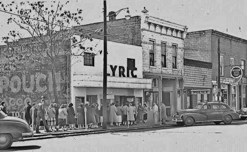
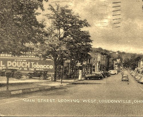
*GONE (sandblasted away)* OH-39 (W. Main Street) in Loudonville. Building is located on the SW corner of the intersection of OH-39 (W. Main Street) and Bentwood Drive. One side of a brick building which is still standing. Black Background.
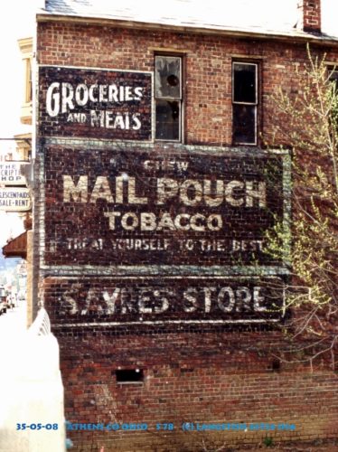
OH Rt. 78 (High Street) along Sunday Creek in Glouster. Heading into Glouster on OH Rt. 78, from the north, the building is on the right side of OH Rt. 78 just across the Sunday Creek bridge. The sign faces north. One side brick building. Black.
