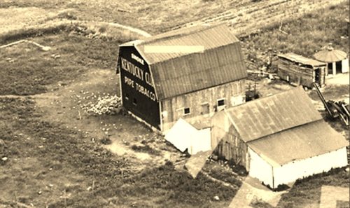
*GONE* (razed and removed) Along the north side of Worthington Rd. east of OH-310 intersection by 0.3 miles. The barn was on the left side of the highway headed east. The Kentucky Club Tobacco sign faced west. One endl Black Background.
*GONE (Barn has been torn down)* Originally at the OH-161/OH-.37 intersection near Alexandria. One end. Red.
US Rt. 40 (National Road Southwest) west of OH Rt. 37 by about 3.0 miles. Two ends. Red. Greatly faded. Building back in the trees and difficult to see.
*GONE* (painted over) Co. Hwy. 41 (Mink St. SW) north of OH Rt. 16 by about 3.2 miles. Almost directly across from the intersection with Twp. Hwy. 159 (Graham Rd. SW). The barn is on the right side of the road headed north. The MP sign faced south. One end. Red Background.
*GONE* (razed and removed) US Rt. 62 (Johnstown-Utica Rd. NW), north of OH Rt. 37 by about 6.9 miles. The barn was on the left side of the highway headed northeast. The Mail Pouch sign faced northeast. One end. Black Background.
*GONE* (Painted and covered by an addition) Co. Hwy. 539 (Raccoon Valley Rd.) east of OH Rt. 37 by about 3.3 miles. The barn is on the east side of the road headed east. The Mail Pouch sign faced east. One end. Black Background.
*GONE (razed and removed)* US Rt. 40 (National Rd SE) east of OH Rt. 79 by 0.5 mile. The barn was on the right side of the highway headed east. The MP sign faced west. One end. Original Black Background.
*GONE* (razed and removed) OH Rt. 13 (Jacksontown Rd.) south of OH Rt.16, in Newark, by 2.9 miles. The barn was on the left side of the highway headed south. The Mail Pouch sign faced south. One side. Black Background.
*GONE* (faded away) US Rt. 40 (National Rd SE), at Linnville, west of the Muskingum County line by about 4.5 miles. The barn is on the right side of the highway headed west. The Mail Pouch end faces south and the Mail Pouch side faces west. One side. One end. Barn has been white washed; however, some parts of the Mail Pouch sign were still bleeding through in 2002. Now faded away and the barn is back off of the road and difficult to see. Black Background.
*GONE* (razed and removed) Along the west side of OH-587, at Willey Rd., north of OH-79 by about 1.7 miles. This barn was on the left side of the highway headed north. One (possible two) end. and One side. Black Backgrounds.
*GONE* (painted over) Along the north side of Worthington Rd. east of the US-62 intersection, in New Albany, by 6.0 miles. (Note: Worthington Rd becomes E. Dublin Grandville Rd. 2.4 miles east of US-62). The barn is on the left side of the road headed east from New Albany. Two ends. Black Background.
*GONE* (Covered/painted over) Along the southeast side of US-62 (Johnstown-Utica Rd. NE) west of OH-13, in Utica, by 2.8 miles. The barn is on the left side of the highway headed west. Two ends. Black Background.
.
*GONE* (razed and removed) Along the southwest side of OH-37 northwest of the US-62 intersection, in Johnstown, by 4.0 miles. The barn was on the left side of the highway headed northwest from Johnstown. There was a Mail Pouch sign on both ends of the barn. Black Backgrounds.
*GONE* (fallen - rubble remains 8/2022) Along the south side of US-40 west of Brownsville Rd (CR-668) by 1.8 miles. The barn rubble is on the left side of the highway headed west. The Mail Pouch sign faced east. One end. Black Background.
Along the south side of W. Broadway west of the N. Prospect St. intersection, in Grandville by 0.8 mile. The barn is on the left side of W. Broadway headed west from Grandville. The Mail Pouch sign faces south. Red backgound.
OH-13 (Jacksontown Rd.) north of US-40 by 2.4 miles and south of MPB 35-45-08 site by 1.9 miles. Directly across from Hirst Rd. (Co. Hwy. 310). The barn is on the left side of the highway headed north. One end Mail Pouch sign faces north. One side Kentucky Club sign faces east. Red backgrounds.
*GONE* (razed and removed) Along the east side of Branch Rd. just past the OH-586 intersection, north of the intersection with OH-16 by 2.3 miles. The barn was on the right side of the road headed north. The Mail Pouch end faced south. The Kentucky Club side faced west. Red Backgrounds.


