- [01] Adams Co, OH (18)
- [02] Allen Co, OH (2)
- [03] Ashland Co, OH (14)
- [04] Ashtabula Co, OH (11)
- [05] Athens Co, OH (20)
- [06] Auglaize Co, OH (5)
- [07] Belmont Co, OH (24)
- [08] Brown Co, OH (32)
- [09] Butler Co, OH (8)
- [10] Carroll Co, OH (22)
- [11] Champaign Co, OH (9)
- [12] Clark Co, OH (3)
- [13] Clermont Co, OH (10)
- [14] Clinton Co, OH (4)
- [15] Columbiana Co, OH (20)
- [16] Coshocton Co, OH (14)
- [17] Crawford Co, OH (13)
- [18] Cuyahoga Co, OH (15)
- [19] Darke Co, OH (8)
- [20] Defiance Co, OH (7)
- [21] Delaware Co, OH (10)
- [22] Erie Co, OH (4)
- [23] Fairfield Co, OH (9)
- [24] Fayette Co, OH (3)
- [25] Franklin Co, OH (12)
- [26] Fulton Co, OH (4)
- [27] Gallia Co, OH (9)
- [28] Geauga Co, OH (10)
- [29] Greene Co, OH (1)
- [30] Guernsey Co, OH (34)
- [31] Hamilton Co, OH (7)
- [32] Hancock Co, OH (5)
- [33] Hardin Co, OH (5)
- [34] Harrison Co, OH (15)
- [35] Henry Co, OH (4)
- [36] Highland Co, OH (15)
- [37] Hocking Co, OH (7)
- [38] Holmes Co, OH (12)
- [39] Huron Co, OH (15)
- [40] Jackson Co, OH (8)
- [41] Jefferson Co, OH (11)
- [42] Knox Co, OH (13)
- [43] Lake Co, OH (2)
- [44] Lawrence Co, OH (9)
- [45] Licking Co, OH (17)
- [46] Logan Co, OH (5)
- [47] Lorain Co, OH (13)
- [48] Lucas Co, OH (5)
- [49] Madison Co, OH (6)
- [50] Mahoning Co, OH (13)
- [51] Marion Co, OH (5)
- [52] Medina Co, OH (9)
- [53] Meigs Co, OH (15)
- [54] Mercer Co, OH (3)
- [55] Miami Co, OH (4)
- [56] Monroe Co, OH (28)
- [57] Montgomery Co, OH (11)
- [58] Morgan Co, OH (20)
- [59] Morrow Co, OH (9)
- [60] Muskingum Co, OH (24)
- [61] Noble Co, OH (15)
- [62] Ottawa Co, OH (8)
- [63] Paulding Co, OH (6)
- [64] Perry Co, OH (8)
- [65] Pickaway Co, OH (7)
- [66] Pike Co, OH (9)
- [67] Portage Co, OH (8)
- [68] Preble Co, OH (9)
- [69] Putnam Co, OH (9)
- [70] Richland Co, OH (11)
- [71] Ross Co, OH (7)
- [72] Sandusky Co, OH (8)
- [73] Scioto Co, OH (16)
- [74] Seneca Co, OH (16)
- [75] Shelby Co, OH (5)
- [76] Stark Co, OH (16)
- [77] Summit Co, OH (5)
- [78] Trumbull Co, OH (3)
- [79] Tuscarawas Co, OH (15)
- [80] Union Co, OH (9)
- [81] Van Wert Co, OH (5)
- [82] Vinton Co, OH (9)
- [83] Warren Co, OH (3)
- [84] Washington Co, OH (34)
- [85] Wayne Co, OH (20)
- [86] Williams Co, OH (4)
- [87] Wood Co, OH (5)
- [88] Wyandot Co, OH (10)
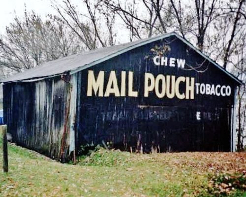
OH Rt. 7 (N. Main St.), north of OH Rt. 553 by about 10.5 miles. The barn is on the right side of the highway headed north. Two ends. Black.
*GONE* (faded away) At the OH Rt. 588 (Indian Creek Dr.)/OH Rt. 325 (W. College St.) intersection. On end. Black Background.
*GONE (razed and removed)* The barn was along the north side of OH Rt. 141 west of the intersection with OH-7, just west of Gallipolis, by 0.8 mile. The barn was on the right side of the highway headed west from Gallipolis. The Mail Pouch sign faced south. One end. Black Background.
*GONE (fallen and removed)* This barn was along CR 160 (Valley View Dr.) and visible from OH Rt. 7 (Ohio River Scenic Byway), south of Chillicothe Rd. intersection, in Gallipolis, by 15.1 miles. The barn was on the right side of the highway headed south on OH-7. Two ends. Black Background.
Along US Rt. 422 east of OH Rt. 88 by 0.5 mile. Building is on the right side of the highway headed east. One end. One side. Black.
Along Music St. west of OH Rt. 44 by about 3.8 miles. The barn is on the left side of Music St. headed west. It is just past Priorway Dr. The
MP sign face north. One end. Black Background.
Along OH Rt. 306 (Chillicothe Rd.) north of OH Rt. 87 by about 1.2 miles. Adjacent to Faith Baptist Church. On the left side of the highway headed north. Just past Dines Rd. The MP sign faces north. One end. Black.
*GONE (fallen and removed)* Along US Rt. 6 east of OH Rt. 166 by about 1.6 miles. The barn was on the right side of the highway headed east. Two ends. Red Background. Greatly faded prior to falling.
At 15559 Munn Rd. (Twp. Hwy. 147) south of Music St. The barn is on the left side of the road headed south. The MP sign faces south. One end. Black.
*GONE (painted over)* Located at 7780 Bainbridge Rd. (Co. Rd. 11) in Chagrin Falls. The barn is on the right side of the road headed west from OH Rt. 306 (Chillicothe Rd.) The MP sign faced east. One end. Black Background.
*GONE* (razerd and removed) Along the west side of Ravenna Rd. (OH-44) south of S Hambden St (US-6), in Chardon, by 2.1 miles. The barn was on the right side of the highway headed south from Chardon. The Mail Pouch sign faced north. Difficult view. The Mail Pouch sign appears to be a Red Background sign.
*GONE* (razed and removed) On the southside of Mayfield Rd (US-322/OH-322) west of the Madison Ave. intersection, in Huntsburg, by 0.4 mile. The barn was on the left side of the highway headed west from Huntsburg. The Mail Pouch signs faced east and west. Two sides. Black Background.
*GONE* (razed and removed) Along the north side of Kinsman Rd. (OH-87) east of the intersection with OH-306, in Russell Center, by 4.7 miles. The barn was on the left side of Kinsman Rd. headed east from Russell Center. The Mail Pouch sign faced west. One end. Black background.
OH Rt. 83 (W. Rd.) south of I-70 by about 1.0 mile. South of New Concord. The building is on the right side of the road headed south. One end. One side. Greatly faded.
*GONE (painted over)* Along Co. Rd. 690 (Bridgewater Rd.) west of I-70/US Rt. 40 exit 193 by about 1.3 miles. The barn is on the right side of the road headed west. The MP sign faced east. One end. MP sign original black. Painted over in red.
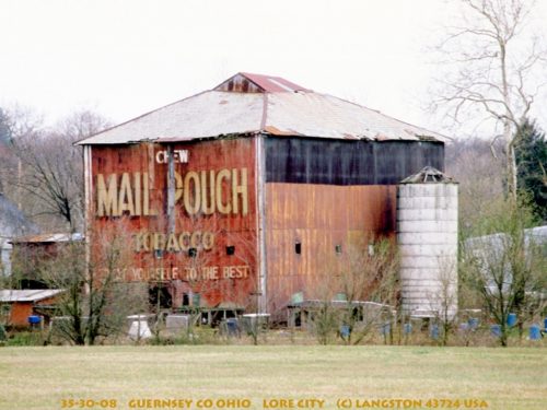
*GONE (fallen and removed)* OH Rt. 285 (Wintergreen Rd.) & OH Rt. 265 (Leatherwood Rd.) intersection, in Lore City. One side. Red.
*GONE* (fallen & removed) Along US Rt. 22 (Cadiz Rd.), southwest of I-77 by about 0.4 mile. When headed southwest on US Rt. 22, from I-77) make a left onto Bottle Ln. (Twp. Hwy. 3665). The barn was immediately on the right. The MP sign faced southwest. One end. Black.
*GONE (razed and removed)* Co. Hwy 35 (old 21 Rd.) southwest of intersection with Co. Hwy. 831 by about 400'. The barn was on the right side of the road headed southwest. Two sides. Black.
*GONE*(razed nd removed) US Rt. 22 (Cadiz Rd.) at Rock Hill Rd. (Co. Hwy. 632) west of Center by about 0.5 mile. The barn was on the right side of the road headed west. The MP sign faced west. One side. Black.
*GONE (fallen and burned)* Along US Rt. 22 (Cadiz Rd.) southwest of OH Rt. 800 by about 1.8 miles. The barn was on the left side of the road headed southwest. One end. One side. Black.
