- [01] Adams Co, PA (2)
- [02] Allegheny Co, PA (32)
- [03] Armstrong Co, PA (13)
- [04] Beaver Co, PA (12)
- [05] Bedford Co, PA (18)
- [06] Berks Co, PA (10)
- [07] Blair Co, PA (4)
- [08] Bradford Co, PA (1)
- [10] Butler Co, PA (19)
- [11] Cambria Co, PA (16)
- [13] Carbon Co, PA (1)
- [14] Centre Co, PA (12)
- [16] Clarion Co, PA (13)
- [17] Clearfield Co, PA (11)
- [18] Clinton Co, PA (6)
- [20] Crawford Co, PA (15)
- [21] Cumberland Co, PA (5)
- [22] Dauphin Co, PA (8)
- [24] Elk Co, PA (2)
- [25] Erie Co, PA (11)
- [26] Fayette Co, PA (29)
- [27] Forest Co, PA (3)
- [28] Franklin Co, PA (4)
- [29] Fulton Co, PA (10)
- [30] Greene Co, PA (29)
- [31] Huntingdon Co, PA (10)
- [32] Indiana Co, PA (14)
- [33] Jefferson Co, PA (11)
- [34] Juniata Co, PA (5)
- [36] Lancaster Co, PA (6)
- [37] Lawrence Co, PA (12)
- [39] Lehigh Co, PA (7)
- [40] Luzerne Co, PA (1)
- [41] Lycoming Co, PA (1)
- [42] McKean Co, PA (8)
- [43] Mercer Co, PA (17)
- [44] Mifflin Co, PA (7)
- [45] Monroe Co, PA (5)
- [46] Montgomery Co, PA (1)
- [47] Montour Co, PA (0)
- [48] Northampton Co, PA (5)
- [49] Northumberland Co, PA (1)
- [50] Perry Co, PA (5)
- [51] Philadelphia Co, PA (1)
- [54] Schuylkill Co, PA (2)
- [56] Somerset Co, PA (22)
- [59] Tioga Co, PA (1)
- [61] Venango Co, PA (7)
- [62] Warren Co, PA (2)
- [63] Washington Co, PA (29)
- [64] Wayne Co, PA (2)
- [65] Westmoreland Co, PA (24)
- [67] York Co, PA (8)
*GONE* Along the southeast side of T695 (Snydertown Rd.) northeast of PA-64 (Nittany Valley Rd.) by about 1.7 miles. The barn was on the right side of the road headed northeast. The Mail Pouch sign faced northeast. One end; Black background.
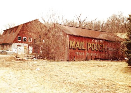
*GONE* (razed and removed) Along the northeast side of PA-144 (N. Main St./Axemann Rd.), in Pleasant Gap, northwest of PA-26 (College Ave.), by about 0.4 mile. The barn was on the right side of the street headed northwest. The Mail Pouch sign faced southeast. One side. Red background.
*GONE* (site has been cleared) Along the southwest side of US-322 S (Flat Rock Rd/28th Division Hwy), northwest of S. Eagle Valley Rd., in Port Matilda, by about 2.5 miles. The barn was on the southwest side of the highway. The Mail Pouch sign faced northwest. One end. Black background.
US-322, west of I-80 exit 11 by 0.3 miles. At Sawyers' Nursery. The barn is on the right side of the highway headed west. One Mail Pouch end faces south and and one Mail Pouch side faces east. Black backgrounds.
*GONE* (fallen) PA-66, south of I-80, exit 64, by about 5.6 miles. The barn is on the left side of the highway headed south. One end. Black.
Along the west side of PA-66, south of I-80, exit 64, by about 7.2 miles. The barn is on the right side of the highway headed south. Two ends. Black backgrounds. Greatly faded.
PA Rt. 66, southwest of PA Rt. 36, in Leper, by about 1.5 miles. The barn is on the left side of the highway headed southwest. The MP sign faces northeast. One side. Black.
*GONE (razed and removed)* PA Rt. 66, southwest of PA Rt. 36, in Leper, by about 5.1 miles. The barn is on the right side of the highway headed southwest. The MP sign faces northeast. One side. Black. Greatly faded.
*GONE* (covered over) PA Rt. 66 northeast of US Rt. 322, in Marianne, by about 1.7 miles. The barn was on the right side of the highway headed northeast. The MP end faced northwest. The MP side faced northeast.
*GONE* (razed and removed - silo remians) Along the west side of PA-208 south of Frayburg Rd. (PA-157/PA-208) intersection, in Fryburg, by 1.0 mile. The barn was on the right side of the highway headed south from Fryburg. The Mail Pouch sign faced north. One end. Black background.
PA Rt. 208 (Fryburg Rd.) northeast of Dempseytown Rd., in Fryburg, by about 2.8 miles. The barn is on the right side of the highway headed northeast. The MP sign faces northeast. One end. Original Black. Faded.
*GONE (razed and removed)* PA-208 (Marble Strobleton Rd) northeast of PA-208/PA-157 interchange north of Fryburg, by about 1.7 miles. The barn was on the right side of the highway headed northeast. The Mail Pouch sign faced west. One end. Black background.
*GONE* (Replaced by a newer barn) PA Rt. 66 (Paint Blvd.) northeast of I-80 by about 4.1 miles. Northeast of US-322, in Marianne, by 0.5 miles. The barn was on the right side of the highway headed northeast. The Mail Pouch sign faced northeast. One end. Black background..
*GONE* (painted over) Along the southeast side of PA-28 (Alexander H. Lindsay Mem. Hwy.) west of the Clarion/Jefferson Co. line by 0.5 miles. Southwest of US-322 (W. Main St.), in Brookville, by about 8.8 miles. The barn is on the left side of the highway headed southwest from Brookville. There was a Mail Pouch sign on each end of the barn. Black Backgrounds.
*GONE* PA-36 northeast of the PA-208/PA-157 intersection north of Frysburg, by about 6.2 miles. Follow PA-208 northeast about 5.0 miles to the intersection with PA-36. Follow PA-36 north 1.2 miles. The barn was on the left (west) side of the highway. The site directly across the highway from the barn location has also been cleared. The Mail Pouch sign faced south. One end (due to the relationship of the highway very possibly two ends). Black background.
*GONE (burned down)* US-219 (Burnside McGee Hwy.) north of St. Rt. 3016 (Byers's Rd.), in Burnside, by about 1.7 miles. The burned barn rubble is on the right side of the highway headed east. Two ends. black.
*GONE* Along the southeast side of US-219 (Mahaffey Grampian Hwy.) south of Main St., in Grampian, by about 3.5 miles. North of PA-969 (Lumber City Hwy.) by about 1.0 mile. The barn was on the left side of the highway headed southwest from Grampian. The Mail Pouch sign faced northwest. One side. Black background.
US-219/US-322 (Carson Hill Rd.), northwest of PA-410 (Shamokin Trail/Luthersburg-Rockton Rd.) intersection, in Luthersburg, by about 1.5 miles. The barn is on the right side of the highway headed northwest. The Mail Pouch sign faces northwest. One. end. black background. Greatly faded.
*GONE (fallen)* On Bell Run Road (T461), just off of US-219 (Mahaffey Grampian Hwy.) To access Bell Run Rd., head south on US-219 about 3.5 miles from the intersection of Main St., in Grampian. Make right onto Bell Run Rd. the barn rubble is almost immediately on the right. One side. Black.
*GONE (painted over)* US-219 S (Chestnut Grove Hwy) northwest of the 1st St. intersection, in Grampion, by about 5.0 miles. The barn is on the left side of the highway headed northwest. The Mail Pouch sign faced northwest. One side. Black background.

