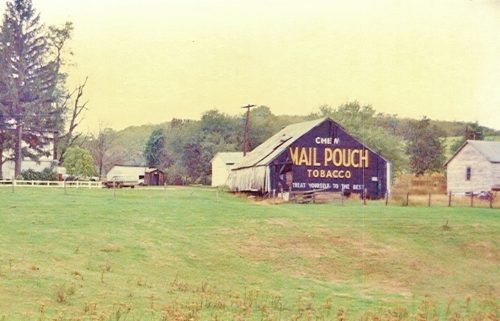
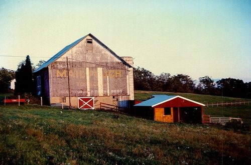
*GONE* (razed and removed) PA Rt. 844 (Jefferson Ave.) southeast of PA Rt. 331 (Bush Run Rd.) intersection by about 0,7 mile. East of The PA/WV state line by about 11.7 miles. The barn was on the left hand side of the highway headed southeast. Two Mail Pouch signs on the barn. One sign on the south side and one sign on the east end. Black Backgrounds.
PA-18 (Prosperity Pike) southwest of PA-18/PA-221 (S. Bridge Rd.) junction, in Prosperity, by about 3.4 miles. The barn is on the right side of the highway headed west. The Mail Pouch sign faces east. One end. Black background.
PA-18 (Prosperity Pike) southwest of PA-18/PA-221 (S. Bridge Rd.) junction, in Prosperity, by about 3.4 miles. The barn is on the right side of the highway headed west. The Mail Pouch sign faces west. One end. Black background.
*GONE (fallen)* US Rt. 40 (E. National Pike), south-east of I-79 by about 3.1 miles. The barn was on the left side of the highway headed southeast. One end (faced southwest) and one side (faced southeast). Black backgrounds.
PA-50 (millers Run Rd.) northeast of PA-519 (Westland Rd.) intersection, in Hickory, by 2 about miles. The barn is on the left side of the highway headed northeast. The Mail Pouch sign faces southwest and is very difficult to see when the trees are in foliage. One end. Black background.
PA-50 (Avella Rd.) southwest of PA-18 (Burgettstown Rd.) junction, (west of Hickory), by about 5.1 miles. The barn is on the right side of the highway headed southwest. The Mail Pouch sign faces east. One side. Black background.
Beallsville Rd. north of US-40 (Main St.) intersection, in Beallsville, by about 1.9 miles. The barn is on the left side of the road headed north. The Mail Pouch sign faces south. One end. Black background. Restored.
Wonsettler Rd. To access the site follow US-40 (E. National Pike) southeast from I-79 (Raymond Shaffer Hwy.) about 5.1 miles to Wonsettler Rd., on the right. Make a right onto Wonsettler Rd. and travel about 250' to the barn on the left side of the road. Partly covered by an addition. Mail Pouch end sign faces north. Mail Pouch side sign faces east. Black backgrounds. Greatly faded.
*GONE (fallen -site cleared)* PA Rt. 18 (Burgettstown Rd./Smith Township State Rd.) northeast of PA Rt. 18 (Main St.) intersection (west of Hickory) by about 2.7 miles. The barn was on the right side of the highway headed northwest, just past the intersection with Covered Bridge Rd. The MP sign faced southeast. One end. black.
*GONE (torn down)* Washington Pike (Morganza Road), just south of the Allegheny county line. Exit off of I-79 at exit 10A, then about a mile to the barn. It was on the right side of the road headed south across the road from Lakeview Christian Life Church. One end. Black.
*Gone* (razed and removed) PA Rt. 136 west of the PA Rt.43 (Mon-Fayette Expressway) intersection by about 4.2 miles. The barn was on the south side of the highway (left side, headed west). The Mail Pouch sign faced west. One end. Black Background.
*GONE (razed and removed)* Along Woodrow Dr. (T Rd 879) just northwest of the intersection with PA Rt. 50 (Avella Rd.) by 0.2 mile. The Woodrow Dr./PA Rt. 50 (Avella Rd.) intersection is southwest of the Wabash Ave. intersection, in Hickory, by about 3.0 miles. The Mail Pouch side of the barn faced southwest toward PA Rt. 50. The Mail Pouch end of the barn faced southeast toward the Woodrow Dr./Avella Rd. intersection. Black background.
*GONE* US Rt. 19 (Amity Ridge Rd.) south of I-79 by about 1.2 miles. The barn was on the right side of the highway headed south. The MP sign faced south. One side. Black.
*GONE* US Rt. 19 just north of Amity. One side. Black.
*GONE* (razed and removed) US Rt. 19 south of I-79 by about 4.4 miles. The barn was on the left side of the highway headed southeast. The MP sign faced southeast. One End. Black.
*GONE (razed and removed)* Steubenville Pike (T Rd. 853) east of the PA Rt. 18 intersection by about 1.0 mile. The barn was on the right side of the highway headed east. The Mail Pouch sign faced east. One side. Black background.
*GONE* (covered over) US-40 west of PA-231 intersection, in Claysville, by about 1.7 miles. The barn is on the right side of the highway headed west. The Mail Pouch sign was on the west end of the barn. One end. Black background.
*GONE (razed and removed)* Steubenville Pike (T. Rt. 853) just west of the PA Rt. 18 intersection by 0.4 mile. The barn was on the left side of the hgihway headed west from PA Rt. 18. The Mail Pouch sign faced northwest. One side. Black background.
*GONE (razed and removed)* Along Cross Creek Rd. west of the Vance Dr./P State Rte. 4033 intersection, in Cross Creek, by about 0.9 mile. the barn was on the right side of the road headed southwest from Cross Creek. The Mail Pouch side of the barn faced southeast. The Mail Pouch end of the barn faced northeast. Black background.
*GONE (razed and removed)* Morganza Rd. north of intersection with W. McMurray Rd. (east of Canonsburg) by about 1.7 miles. The barn was on the left side of the road headed north from W. McMurray Rd. The Mail Pouch sign faced southeast. One side. Black background.


