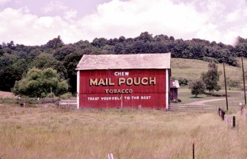
*GONE* US Rt. 422 (Benjamin Franklin Hwy.) east of PA Rt. 56/PA Rt. 156, in Shelocta, by about 0.7 miles. The barn was on the right side of the highway headed east. The MP sign faced east. One end. Black.
*GONE (razed and removed)* US Rt. 422 (Benjamin Franklin Hwy.) southeast of the intersection with PA Rt. 403, near Strongstown, by 0.3 mile. The barn was on the right side of the highway headed southeast. The Mail Pouch sign faced southeast. One end. Black.
*GONE* (razed and removed) Rayne Church Rd. northwest of PA-286 (Clymer Rd.) by about 360'. To access the site take PA-286 (Clymer Rd.) west from the PA-403 (Penn St.) intersection, in Clymer, for about 3.2 miles to Rayne Church Rd. Make right onto Rayne Church Rd. The barn was on the right side of the road. The Mail Pouch sign faced southwest. One side. Black Background.
*GONE* PA Rt. 286 northeast of Washington St. intersection, in Saltsburg by about 4.9 miles. The barn was on the left side of the highway headed northeast. The barn backed up on Young Rd. The Mail Pouch sign faced south. One side. Original Black background, the barn had been painted red and the old sign was bleeding through.
*GONE (faded away)* PA Rt. 286 (Clymer Rd.) northeast of Airport Rd. intersection by 3.0 miles. The Airport Rd. to Indiana Co./Jimmy Stewart Field, is just east of Indiana, and west of US Rt. 119. The barn is on the right side of PA Rt. 289 headed northeast. The Mail Pouch sign faced northeast. One side. Black background.
*GONE* Along the south side of William Penn Hwy. (US-22). The barn was on the left side of US-22 headed east. The barn was also along the north side of E. Philadelphia St. Ext. east of Indiana St. (PA-56), in Armagh, by 0.7 miles. The Mail Pouch sign faced east. One side. Black background.
*GONE (razed and removed)* US Rt. 119 (Pittsburgh-Buffalo Highway) at the intersection with Johnson Rd.. The Johnson Rd. intersection is northeast of PA Rt. 85 intersection, in Home, by 6.8 miles. The barn was on the left side of the highway headed north. The Mail Pouch sign faced south. One side. Red background.
*GONE* (razed and removed) Along the northeast side of Gas Center Rd, southeast of the William Penn Hwy (US-22) intersection (east of Armagh) by 0.5 mile. The barn was along the left side of Gas Center Rd, headed southeast of US-22. The Mail Pouch sign faced southwest. One side. Black background.
PA Rt. 286 northeast of PA Rt. 403 (2nd St.) intersection, in Clymer. The barn is on the right side of the highway headed northeast. It is in the tress on the hillside and very difficult to see from the road. The MP sign faces north. One side. Black.
*GONE (razed and removed)* The barn was located along old Rt. 119 Hwy. N. north of Philadelphia St. intersection, in Indiana, by 2.8 miles. The barn was on the right side of the highway headed north. The Mail Pouch sign faced west. One side. Black background.
*GONE(covered over)* US Rt. 119 (Pittsburgh-Buffalo Hwy.) northeast of PA Rt. 85 intersection, in Home, by about 4.6 miles. The barn is on the right side of the highway headed north. The barn backs up on Wilmoth Rd. The Mail Pouch sign faced west. One end. Black background.
*GONE (razed and removed)* Along old US Rt. 22, (now Penn View Rd.) east of the US Rt. 119 intersection by about 3.9 miles. The barn was on the right side of the highway headed east. The Mail Pouch sign faced east. The barn and the adjacent residence were razed and removed when US Rt. 22 was re-routed. One end. Black background.
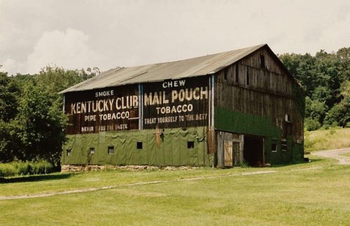
*GONE (razed and removed)* PA Rt. 56 east of US Rt. 119 (Buffalo-Pittsburgh Hwy.), in Homer City, by about 2.5 miles. The barn is on the left side of the highway headed northeast. One end MP sign faces southwest; and one side MP sign and KC sign faces southeast. Black.
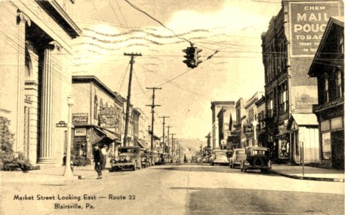
*GONE (razed and removed)* E. Market St. (old US Rt. 22), in Blairsville, east of S. Walnut St. by about 90'. The three-story brick building was on the right side of the street headed east. The MP sign faced west. One side. three-story brick building. Original Black background.


