- [BAP] Battle Ax Plug (12)
- [BBC] Big Ben Cigars (1)
- [BCS] Baltimore Cigars (3)
- [BDB/BDS] Bull Durham (240)
- [BJT] Black Jack Tobacco (1)
- [BXC] Baxter Cigars (1)
- [CCB] Cubanola Cigars (2)
- [CCS] Charter Cigars (1)
- [CRC] Cremo Cigars (2)
- [DCC] Dry Climate Cigars (2)
- [DNT] Day & Night Tobacco (1)
- [FBC] Five Brothers Cigars (1)
- [GAC] General Arthur Cigars (4)
- [GCC] General Colfax Cigars (3)
- [GRB] Gold River (1)
- [GRT] Grape Tobacco (1)
- [GTS] Greenback Tobacco (5)
- [HGC] Henry George Cigars (45)
- [HSS] Honest Scrap (19)
- [KCS/KCB] Kentucky Club (57)
- [LCS] Lovera Cigars (1)
- [LTS] Liberty Tobacco (1)
- [MCB/MCS] Melo Crown (31)
- [MOC] M & O Cigars (5)
- [MWS] Marsh Wheeling Stogies (1)
- [OHB/OHS] Old Hillside (8)
- [OLB] Old Loyalty (1)
- [OWL] Owl Cigars (76)
- [PTS] Partner Tobacco (1)
- [RJR] RJ Reynolds (2)
- [RMB/RMS] Red Man (13)
- [SCT] Silver Cup Tobacco (0)
- [SFC] San Felice Cigars (1)
- [STR] Star Tobacco (7)
- [STS] Sensation Tobacco (1)
- [TMC] Tom Moore Cigars (6)
- [WCS] Webster Cigars (1)
- [WOW] WOW Tobacco (38)
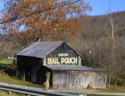
*GONE (fallen)* US Rt. 52 (Main St.), west of OH Rt. 222, in Chilo by 2.4 miles. Just northwest of the Meldahl Dam access road. The barn was on the right side headed northwest from OH Rt. 222. The MP/MC sign faced southeast. One end. Black.
*GONE* (faded away and painted over)US Rt. 22(Cincinnati Zanesville Rd. SW) east of OH Rt. 674(Winchester Southern Rd.) by about 1.7 miles. The barn is on the right side of the highway headed northeast. Two signs. The MP/MC sign faced northeast. The MP sign faced southwest. Two ends. Black Background.
*GONE* (razed and removed) Along the north side of W. Akron - Canfield Rd./US Rt. 224, west of OH Rt. 45, in Ellsworth, by 2.7 miles. The barn was on the right side of the road headed west from Ellsworth. Two ends & One side. Mail Pouch sign on the west end. Melo-Crown Stogies on the east end (Previous to the Melo-Crown sign a Mail Pouch sign was on the east end). Mail Pouch sign on the south side. Black backgrounds.
*GONE* (fallen & removed) Along the south side of Tallmadge Rd. (CR-18) west of OH-225, in Palmyra, by 2.3 miles. The barn was on the left side of the road headed west from Plamyra. The Mail Pouch sign faced east. One end. Black Background. The Melo-Crown sign was barely visible.
*GONE* (fallen) Along the northeast side of OH-125 northwest of US-52, in Friendship, by 3.2 miles. Two ends. There was a Mail Pouch sign with very faint Melo Crown sign on the southeast end of the barn; and, a Mail Pouch sign on the northwest end of the barn. Black Backgrounds.
*GONE* (razed and removed) Along the west side of US-19, north of PA-68 by 3.2 miles. About 250 feet south of Schott Lane intersection with US-19, on the right side, headed south. One end and one side, both facing south. Black backgrounds.
*GONE* (razed and removed) Along the southwest side of Oneida Valley Rd. (PA-38) north of US-422 (Benjamin Franklin Hwy.) by about 7.8 miles. The barn was on the left side of the highway headed north. The MP/MC sign faced north. One end. Black backgrounds.
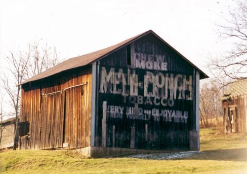
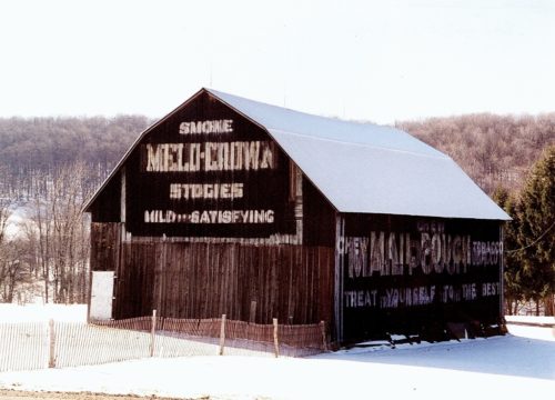
Along the west side of PA-77 (Spartansburg Hwy.) south of W, Main St., in Corry by about 3.3 miles. The barn is on the right side of the highway headed south. The Mail Pouch side faces north. The Melo Crown end faces east. Black backgrounds.
Along the east side of N. Perry Hwy. (US-19) north of Franklin Rd. (US-62) intersection, in Mercer, by 10.4 miles. The barn is on the right side of the highway headed north. the signs (Mail Pouch and Melo Crown) face north. Greatly faded. Black Background.
*GONE* (fallen & removed) PA-157 southeast of US-62 (President Rd.) by about 1.8 miles. The barn was on the left side of the highway headed east. One end. Black background.
*GONE* Along the north side of Old. US-50 (CR-50/30; Smithson Rd.) west of US-50 intersection by about 0.8 miles. The barn was on the right side of the road headed northwest. Mail Pouch signs on the Northwest and southeast sides. Melo Crown sign on the northeast end. Black backgrounds.
Along the north west side of Northwestern Pike (US-50/WV-28) east of US-220 intersection by about 2.2 miles. The barn is on the left side of the highway headed east. Two ends. One side. Black backgrounds.
*GONE* (razed and removed) Along the southeast side of WV-2 (Huntington Rd.) south of US-35 by 18.1 miles. The barn is on the left side of the highway headed southwest. Mail Pouch and Melo Crown Stogie signs faced northwest. One side. Black backgrounds.
*GONE* (faded away) Along the east side of WV-62 (Charleston Rd.) north of the Allen St. (cr 1/1), in Buffalo, by 6.0 miles. North of the MPB 48-26-06 site by 0.3 mile. The barn is on the right side of the highway headed north. The Mail Pouch & Melo Crown Stogies signs faced west. One side. Original Black backgrounds.
Along the northeast side of N Preston HWY (WV-26) south of I-68 exit 23 by about 2.2 miles. At about the 2.2 mile point south of I-68 there is a road that leaves the highway on the left side and enters a pasture beyond the trees. Take the road into the pasture, the barn is on the left side. The Mail Pouch sign faces south and is only visible driving north on WV-26. One end. Black background. Faded.
*GONE* (fallen and removed) Along the southeast side of Charleston Rd. (US-119) south of US-33 (Main St.), in Spencer, by about 3.75 miles. The barn was on the left side of the highway headed southwest. Mail Pouch end faced northeast. Mail Pouch side faced northwest. Black backgrounds.
*GONE* Along the southeast side of Energy Hwy (WV-2) northern edge of Friendly. North of intersection with Front St., in Friendly, by 0.1 mile. The barn was on the right side of the highway headed northeast away from Friendly. The Mail Pouch side faced northwest. The Melo Crown end faced northeast. Black backgrounds.
OH Rt. 128 (Hamilton Cleves Pike Rd.) west of I-74/I-275/US Rt. 52 by about 2.5 miles. Take exit 7 to OH Rt. 128 (Hamilton Cleves Pike Rd.) and head west. The barn is on the right side of the road headed west. Two ends. One side. Black.
OH Rt. 26, south of OH Rt. 800 by about 1.4 miles. The barn is on the right side of the highway headed south. Two ends and one side. Black.
US Rt. 219/WV Rt. 55 south of US Rt. 250 by about 9.8 miles. The barn is on the left side of the highway headed south. Two ends. One side. black.
