- [01] Barbour Co, WV (9)
- [02] Berkeley Co, WV (2)
- [03] Boone Co, WV (4)
- [04] Braxton Co, WV (7)
- [05] Brooke Co, WV (2)
- [06] Cabell Co, WV (8)
- [07] Calhoun Co, WV (6)
- [09] Doddridge Co, WV (3)
- [10] Fayette Co, WV (4)
- [11] Gilmer Co, WV (2)
- [13] Greenbrier Co, WV (5)
- [14] Hampshire Co, WV (7)
- [15] Hancock Co, WV (1)
- [16] Hardy Co, WV (0)
- [17] Harrison Co, WV (7)
- [18] Jackson Co, WV (12)
- [20] Kanawha Co, WV (6)
- [21] Lewis Co, WV (5)
- [22] Lincoln Co, WV (8)
- [23] Logan Co, WV (0)
- [24] Marion Co, WV (16)
- [25] Marshall Co, WV (14)
- [26] Mason Co, WV (12)
- [29] Mineral Co, WV (5)
- [31] Monongalia Co, WV (8)
- [32] Monroe Co, WV (1)
- [33] Morgan Co, WV (1)
- [34] Nicholas Co, WV (5)
- [35] Ohio Co, WV (16)
- [37] Pleasants Co, WV (3)
- [38] Pocahontas Co, WV (3)
- [39] Preston Co, WV (6)
- [40] Putnam Co, WV (4)
- [41] Raleigh Co, WV (0)
- [42] Randolph Co, WV (11)
- [43] Ritchie Co, WV (8)
- [44] Roane Co, WV (6)
- [46] Taylor Co, WV (14)
- [47] Tucker Co, WV (1)
- [48] Tyler Co, WV (4)
- [49] Upshur Co, WV (5)
- [50] Wayne Co, WV (10)
- [51] Webster Co, WV (4)
- [52] Wetzel Co, WV (4)
- [53] Wirt Co, WV (5)
- [54] Wood Co, WV (15)
*GONE* (faded away) Along the northeast side of W. Main St., northwest of the Columbia St. intersection,in West Union, by about 75'.
The Bull Durham sign faced southeast. One side. Original black background.
*GONE (building razed)* Appears to have faced on Washington street northeast of the intersection with Jefferson St., in Fairmont. One side. Black background. Bull Durham sign faced southeast toward the river.
*GONE* (razed and removed) Northeast of the bridge landing on the Morgantown side of the Monongahela River and facing the river.
*GONE* In Sistersville, Exact location unknown.One end. Black background.
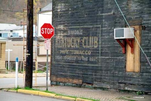
*GONE* (razed and removed) Along the northwest side of Ripley Rd. (US-33) west of the intersection with Black Walnut Ave., in Spencer, by 2.4 miles. Note that Ripley Rd. becomes Main St. at the Locust Ave. intersection in Spencer. The Kentucky Club sign faced southwest. One end; Black background.
*GONE* (razed and removed - July 2019) Southwest corner of Jacob St. & 40th St., in Wheeling. The building (an old bar) was on the right side of 40th St. headed from Water St. toward Jacob St. The KC sign faces north. One side. Three story, wood frame building formerly used as a bar. Original Black Background.
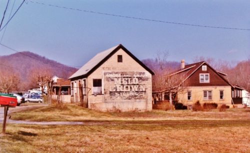
*Gone* (razed and removed) Along the southeast side of Elk River Rd. N (US-119), southwest of WV-4 junction, in Clendenin, by about 6.5 miles. The building was on the left side of the highway headed southwest. The Melo Crown sign faced southwest. One end. Black background.
Along the west side of US-250 (Junior-Philippi-Grafton Rd.) south of US-119 by about 3.9 miles. The barn is on the right side of the road headed south and is off in the distance. The Mail Pouch sign faces southeast. One side. Black background.
Along the west side of WV-92 (Morgantown Pike) north of US-250 (Junior-Philippi-Grafton Rd.), in Belington, by about 1.0 mile. The barn is on the left side of the highway headed northeast. The Mail Pouch sign faces east. One end. Black background.
*GONE* Northeast corner of Old US Rt 250 & Briar Patch Rd. (Co. Rt. 250/6) intersection. Take US Rt. 250 (Barbour Co. Hwy) south from US Rt. 119, in Philippi, about 5.0 miles to Briar Patch Rd. Make right onto Briar Patch Rd. (Co. Rt. 250/6). The site is on the right side of the road just before Old US Rt. 250 intersection. The MP sign faced west. One side. Black.
*GONE* The Mail Pouch sign was visible from US Rt. 250 (S. Main St./Barbour Co. Hwy.) south of US Rt. 119 by about 1.6 miles. The barn was on the left side of the highway headed southeast. The barn was almost directly across from the Gunnia Grove Rd. intersection. The MP sign faced southwest. One side. Black.
*GONE* (razed and removed) Along the east side of Barbour County Hwy (US-250), south of teh Blue & Gray Expy. intersection, in Philippi, by 4.2 miles. The barn was on the left side of the highway headed south. The Mail Pouch sign faced north. One side. Black background.
*GONE* Belington.
*GONE* (razed and removed) Along the northeast side of Valley Bend Rd (0ld US-250) north of the US-250 intersection by 0.2 mile. The barn was on the right side of the road headed northwest. Mail Pouch side faced southwest. Mail Pouch end face southeast. Black backgrounds.
WV-9 (Hedgesville Rd.) northwest of WV-901 (Mary St.), in Hedgesville, by about 5.0 miles. The barn is on the left side of the highway headed northwest. The Mail Pouch sign faces north. One end. In 1973 the Background color was red. By 1987, after a repaint, the Background color had been changed to black.
*GONE* (razed and removed), Along the northeast side of Hedgesville Rd (WV-9) southeast of the intersection with Mary St, in Hedgesville by 0.4 mile. The barn was on the left side of the highway headed southeast. The were two Mail Pouch signs on the barn. One on the southeast end of the barn and the other on the northwest side of the barn. Red Backgrounds.
*GONE (razed and removed)* WV Rt. 17 (Spruce Fork Rd.) south of WV-85, in Madison, by about 1.75 miles. The shed was on the left side of the highway headed southeast. The Mail Pouch sign faced southwest. One side. Black.
*GONE (razed and removed)* Along the west side of Coal River Rd. (WV-3) south of Sherman Sr. HS, in Seth, by 2.7 miles. The garage was on the right side of Coal River Rd. (WV-3) headed south. The Mail Pouch sign was on the south side of the garage. One side. Black background.
*GONE* (razed and removed) US Rt. 19/WV Rt. 4 east of WV Rt. 5 by about 1.5 miles. The barn was on the right side of the highway headed northeast. The MP sign faced north. One side. Black.
*GONE (Razed and removed)* US Rt. 19/WV Rt. 4 (Gauley Turnpike) northwest of I-&( exit 67 by 7.8 miles. The barn was on the left side of the highway headed northeast. The MP sign faced southwest. One end. Black.


