Other Information
Larry Zinn's location information was simply 'US-219 south of Elkins'.
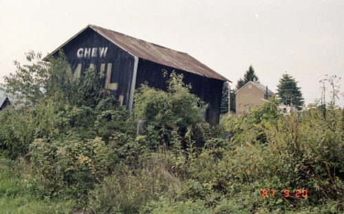
This barn was finally located using Historic Aerials' imagery. The barn is clearly visible in 1981 imagery. Reviewing the details in Photo 1, there is the peak of a building at the very left of the barn. In the distance there is a distinctive house with additions to the east side of the house. In addition, there is a grove of tall pines just beyond and to the left of the house and a single large pine to the right of the main part of the house beyond the addtion. All of these features are clearly visible in the Historic Aerials imagery (1981). The distance measurement tool was used and the red pin on Photo 5 is the location where the Mail Pouch barn once stood. The south end of the barn (with the Mail Pouch sign) appears to be within 10-12 feet of Scotts Lake Rd. which would have made the Mail Pouch sign very visible to traffic travelling north on Seneca Trail (US-219). The barn belonged to the farmhouse in the distance, in Photo 1 and the address for the entry is based on the address for the farm house.
Photo 4 is a view looking from Seneca Trail (US-219) toward where the Mail Pouch barn once stood. The road in the view is Scotts Lake Rd. There is a Historic Marker along the road. The Mail Pouch barn would have been approximately 10-12 feet from the edge of Scotts Lake Rd. in the general vicinity of the Historic Marker.
Where to find it *GONE* (razed and removed) Along the east side of Seneca Trail (WV-55/WV-92/US-219/US-250) south of Court St. intersection, in Beverly, by 1.9 miles. The barn was on the left side of Seneca Trail headed south from Beverly. The Mail Pouch barn south end faced on Scotts Lake Rd. One end. Black background.


