- [02] Allegany Co, NY (1)
- [04] Broome Co, NY (1)
- [05] Cattaraugus Co, NY (11)
- [07] Chautauqua Co, NY (6)
- [12] Cortland Co, NY (1)
- [14] Dutchess Co, NY (3)
- [15] Erie Co, NY (11)
- [19] Genesee Co, NY (2)
- [22] Herkimer Co, NY (1)
- [25] Lewis Co, NY (1)
- [28] Monroe Co, NY (1)
- [32] Niagara Co, NY (7)
- [33] Oneida Co, NY (1)
- [34] Onondaga Co, NY (1)
- [36] Orange Co, NY (1)
- [37] Orleans Co, NY (3)
- [39] Otsego Co, NY (2)
- [41] Queens Co, NY (1)
- [50] Seneca Co, NY (1)
- [54] Tioga Co, NY (4)
- [58] Washington Co, NY (1)
- [59] Wayne Co, NY (1)
*GONE (painted over)* US Rt. 20 (E. Main St./Main Rd.) northeast of NY Rt. 394 (Portage Rd.), in Westfield, by about 3.1 miles. The barn is on the right side of the highway headed northeast. The MP sign faced northwest. One end. Original Black background.
*GONE* NY Rt. 60 north of Gerry by about 0.5 mile. The barn was on the left side of the highway headed north. The MP sign faced north. One end. Black.
*GONE (painted over)* US Rt. 62 (Main St.), west of the Pearl St. intersection, in Frewsburg, by 0.3 mile. The barn is on the left side of the highway headed west from Frewsburg. The MP sign faced west. One end. Black.
*GONE* (faded away) US-20 (W. Main Rd./Main St./Main Rd.) northeast of the Pennsylvania state line by about 7.7 miles. Northeast of NY-76 (State St.), in Ripley, by about 4.6 miles. Just east of Rogerville Road. The barn is on the left side of the highway headed northeast. One end. Black background.
*GONE* (faded away) NY Rt. 60 north of the crossroads, in Gerry by 7.7 miles. The barn is on the right side of the highway headed north. The MP sign faces north. One end. Black.
Duell Rd. south of Hunns Lake Rd., in Bangall, by about 1.1 miles. From Hunns Lake Rd. head south on Bangall Armenia Rd. for about 0.1 mile and bear right onto Duell Rd. Follow Duell Rd. south about 1.0 mile to the barn on the left side of the road. The MP sign faces south. One side. Black. Greatly faded.
*GONE* NY Rt. 270 south of the Niagara Co. line. One end. Black.
*GONE* NY Rt. 240 near Springville. One end. Origina Black background.
*GONE (fallen and removed)* NY Rt. 354 (Clinton St.) east of US Rt. 20/NY Rt. 78 (Transit Rd.) by about 2.9 miles. Just past the intersection with Bowen Rd. The barn was on the left side of the hgihway headed east. The MP sign faced east. One end. Black.
*GONE* (razed and removed) Along the west side of S. Protection Rd. (T-392) north of the intersection with Olean Rd (NY-16) by 0.8 mile. The barn was on the left side of the road headed north. The Mail Pouch sign was on the west side of the barn and faced Olean Rd (NY-16). One side. Black background.
*GONE* (fallen and removed) NY Rt. 39 west of US Rt. 219, at Springville, by about 1.2 miles. The barn was on the right side of the highway headed northwest The MP sign faced southeast. One side. Black.
*GONE* (fallen) NY Rt. 39 west of US Rt. 219 by about 1.0 mile. The barn was on the left side of the highway headed west. The MP sign faced north. One side. Black. Greatly faded.
*GONE (fallen)* NY Rt. 33 (Genesee St.) east of NY Rt. 78 (Transit Rd.) in Bowmansville by about 4.0 miles. The barn was on the right side of the highway headed east. The MP sign faced west. One side. black.
*GONE* (fallen and removed) NY Rt. 33 (Genesee St.) east of NY Rt. 78 (Transit Rd.) in Bowmansville by about 9.7 miles. The barn was on the left side of the highway headed east. The MP sign faced east. One side. Black.
*GONE* (painted over) NY Rt. 33 (13296 Genesee St.) west of NY Rt. 77 (Allegheny Rd.), in Corfu, by about 4.5 miles. The barn is on the right side of the highway and very difficult to see because of the houses and the trees. Two ends. Red.
*GONE* (razed and removed) NY Rt. 270 (Campbell Blvd.) north of NY Rt. 263 (Millersport Hwy.), in Getzville, by about 2.2 miles. The barn was on the right side of the highway headed north. The MP sign faced north. One end. Black.
NY Rt. 270 (Campbell Blvd.) north of NY Rt. 263 (Millersport Hwy.), in Getzville, by about 3.1 miles. The barn is on the right side of the highway headed north The MP sign faces south One end. Black.
Asbury Rd. south of NY Rt. 5 (E. Main Rd.) by about 2.2 miles. The NY Rt. 5 & Asbury Rd. intersection is east of NY Rt. 19 (Lake St./Clay St.), in LeRoy, by about 1.4 miles. The barn is on the left side of Asbury Rd. headed south. The MP sign faces north. One end. Black.
*GONE* (faded away and subsequently painted over) NY Rt. 33 (Clinton Street Rd.) northeast of NY Rt. 5 (E. Main St.), in Batavia, by about 7.4 miles. The barn is on the left side of the highway headed northeast. The MP sign faces southwest. One side. Original black. Greatly faded and overpowered by a 'ghost' GROTON sign.
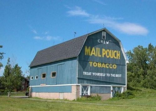
Along the west side of Akron Rd. (NY-93) east of S. Transit Rd. (NY-78) intersection, by 6-5 miles. The barn is on the right side of NY-93 headed south. The NY-93/NY-78 intersection is south of NY-31 intersection, in Lockport, by about 2.5 miles. The Mail Pouch sign faces south. One end. Blue background.


