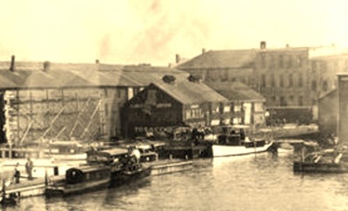
Photo 1 is an enlarged inset view from Photo 2.
Photo 3 is copied from an article "History of Sandusky Yacht Club".
The following paragraph is copied from "History of Sandusky Yacht Club" (The original clubhouse of the Sandusky Yacht Club, was situated near the foot of Columbus Ave. It was later moved out from shore and placed on cribbing. This created a semi-closed harbor for mooring boats. This structure served its purpose well until a tornado swept through Sandusky in the summer of 1924 and demolished most of the waterfront. No part of the building was ever found.) Note: Original club was situated near the foot of Columbus Ave.
Photo 4 Notice the roof lines of the three buildings circled in lime. These buildings along with the location of the foot of Columbus Ave. were used in searching the ODOT aerial Photos.
The Ohio Dept of Transportation aerial photo archives were used in locating where the Sandusky Yacht Club was once located. Photo 5 the three builldings referenced in previous note are circled in lime. The approximate former location of the building with the Mail Pouch signs is circled in yellow.
Photo 6 (Google satellite image) has the approximate location of where the building with the Mail Pouch signs was located noted by the red pin. This pin was used to determine the address and the coordinates. The three bulidings circled in lime in Photo 3 are circled in lime in this image. Also, Columbus Ave. is circled in red.
Photo 7 (Google street view) has the three buildings circled in lime. They have undergone architectural changes over the years; however, the similarities that remian confirm them as the same buildings shown in Photo 3.


