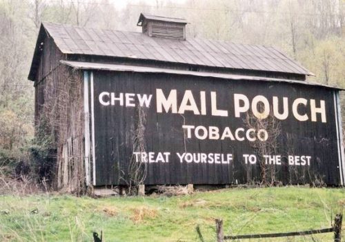
Larry Zinn's note for location of this barn was 'JUST SOUTH' of the barn ID'd as MNPB 48-52-02, which is still existing (2023) along Energy Hwy (WV-2), in Wetzel Co. WV. Initially, bassed on the limited information a 'BEST GUESS' location was selected for this barn, just south of MPB 48-52-02.
During the time of the upload of the new Mail Pouch Barnstormer's website, it was decided to take a second look at the 'BEST GUESS' location for this barn. Two resources were used. 1) Historic Aerials' imagery website; and, 2) Larry Zinn's binder holding all of the film negatives for the Mail Pouch photos he had taken.
The negatives for this barn were located in the binder. The film strips not only included this barn but also three additional barns. Each frame of the film strip was numbered which would allow for the sequencing of the barn locations. Frame numbers 1-4 are photos of a barn ID'd as MPB 48-48-04 positively located in the Sistersville area, Tyler Co, WV; Frame numbers 5-9 are photos of a barn ID'd as MPB/MCB 48-48-03 positively located just north of Friendly WV, Tyler Co.WV. Frame numbers 10-13 are photos of this barn (MPB 48-37-02); and, Frame numbers 14-16 are photos of the barn ID'd as MPB 35-84-10 positively located north of Marietta, Ohio along OH-7. Since Larry Zinn mentioned that this barn was along WV-2 it would suggest that after photographing MPB 35-84-10, north of Marietta, he would have continued north to the Hi-Carpenter bridge and crossed the Ohio River into West Virginia just south of St. Marys and then turned north and followed WV-2 north toward New Martinsville.
The Historic Aerials' imagery (1972) was used to follow along WV-2 from St. Marys to Friendly, WV where the last positively ID'd barn was located MPB/MCB 48-48-03. The barn, distinguished by it's rectangular roof ventilator and the shed extension along the side, in addition to the small
building noted at the left in Photos 2 & 3 were clearly visible. The distance measurement tool was used to obtain the decimal coordinates for the Mail Pouch barn and the red pin on Photo 9 is the location where the barn was once located. The coordinates were used to determine the address for the entry.
Photo 7 is an April Google street view. In the distance in the shrubs there is a remnant of the old barn. In all the other Google street views the shrubs and foliage completely obscure the barn remants.


