MPB 38-31-05

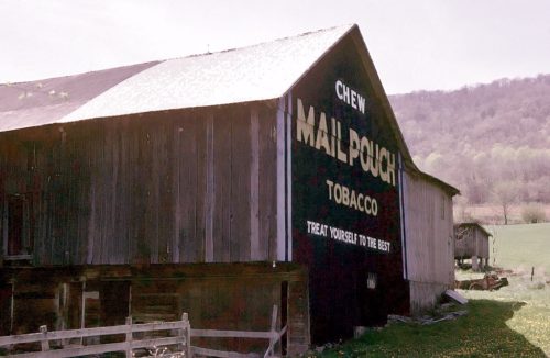
Photo 1
Sides Painted
1
Color
Black
Structure
Barn
Unique Characteristics
None
Still Standing
No
Credits

Photo 1 by Fred Yenerall (Oct. 1978 - Submitted by Judy Thomas).

Photo 2 by unknown VA # 51-BHU-14 (1978) courtesy of Vintage Aerial

Photo 3 by unknown VA # 74-HHU-27 (1982) courtesy of Vintage Aerial

Photo 4 by Tom Fritsch (1990). 

Photo 5 by unknown VA # 18-PHU-14 (1992) courtesy of Vintage Aerial

Photo 6  by Darlene & Ernest Ferretti (1993).

Photo 7 Google street view (Sept. 2008).

Photo 8 Google satellite image
Other Information

The green arrow in photo 8 and the GPS coordinates are centered on the old barn foundation.

Photo 6 is a view of the barn rubble taken in 1993.

Photo 7 is a Google Street view showing the site cleared.
Where to find it

*GONE (destroyed by a storm in 1993)* US Rt. 522 (Croghan Rd.) northwest of PA Rt. 641 intersection, in Shade Gap, by about 2.4 miles. The barn was on the left side of the highway headed north. The MP sign faced north. One end. Black.
Address
20816 Croghan Pike (US-522)
City
Orbisonia
State
PA
Zipcode
17243
Country
USA
Latitude
N 40° 12.49'
Longitude
W -77° 52.63'
lat
40.20812931
lng
-77.87730748
  • Photo 2
  • Photo 3
  • Photo 4
  • Photo 5
  • Photo 6
  • Photo 7
  • Photo 8