MPB 38-03-01

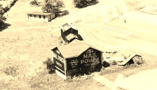
Photo 1
Sides Painted
2
Color
Black
Structure
Barn
Unique Characteristics
None
Still Standing
No
Credits

Photos 1 & 2 by unknown VA # 015-SAR-34 (1981) courtesy of Vintage Aerial

Photos 3 & 4 by Bill Plack (1987).

Photo 5 by Dave and Mary Ann Shaver (Sept. 12, 1987). 

Photo 6 by Emerson Miller (1992 - from album donated by daughter Darlene Long). 

Photo 7 by unknown (July 5, 1993).

Photo 8 by unknown. 

Photo 9 by Dave Tower (Mar. 31, 1998). 

Photo 10 by Dave Tower (May 27, 1998). 

Photo 11 by Lonnie Schnauffer (June 1998). 

Photos 12-15 by Dave Tower (Nov. 26, 1998). 

Photos 16 & 17 by Lonnie Schnauffer (Apr. 1999). 

Photo 18 by Dave Tower (May 1999). 

Photo 19 by Lonnie Schnauffer (Aug. 2001). 

Photo 20 by unknown (2001).

Photo 21 Google Street view (Oct. 2016).
Other Information

Photo 1 is an enlarged inset view from Photo 2.
Where to find it

*GONE (fallen down)* Along the northwest side of PA-28/PA-66 (Alexander H. Lindsay Memorial Hwy.), north of    US-422 by about 3.4 miles. The barn was on the left side of the highway headed northeast. One end - faced southeast. One side - faced northeast. Black backgrounds.

Address
763 Alexander H. Lindsay Memorial Hwy. (PA-28/PA-66)
City
Kittanning
State
PA
Zipcode
16201
Country
USA
Latitude
N 40° 50.69'
Longitude
W -79° 27.84
lat
40.84485441
lng
-79.46400387
  • Photo 2
  • Photo 3
  • Photo 4
  • Photo 5
  • Photo 6
  • Photo 7
  • Photo 8
  • Photo 9
  • Photo 10
  • Photo 11
  • Photo 12
  • Photo 13
  • Photo 14
  • Photo 15
  • Photo 16
  • Photo 17
  • Photo 18
  • Photo 19
  • Photo 20
  • Photo 21