Credits
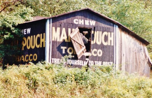
Photos 1-6 by Larry Zinn (Sept. 20, 1987 - contributed by Butch Moon).
Photo 7 by Steven Rotsch (1996).
Photo 8 Google street view (Oct. 2007).
Photo 9 Google satellite image.
Other Information
This Mail Pouch barn is clearly visible in Historic Aerials' imagery. The building to the right of the view in Photo 4 is also visible in the imagery. The distance measurement tool was used to obtain the decimal coordinates of the barn. The coordinates were input to the Google map program and the red pin on Photo 9 is the location where the Mail Pouch barn once stood. The coordinates were used to determine the address for the entry.
As a note to Photo 7, Steve writes: '...I noticed this barn while driving along during the winter and could not help to be amazed by the way it had collapsed. As you can see by the photo both sides had collapsed leaving the letters OUCH!'
Photo 8 is a view from Mountain parkway looking in at the site. Historic Aerials' imagery shows that the rubble from the fallen barn, shown in Photo 7 had been removed by 1997.
Where to find it *GONE* (fallen and removed) Along the southeast side of Mountain Valley Pkwy. (WV-20), in Hacker Valley, southwest of the intersection with School Loop Rd./Valley Dr. intersection by about 430'. The barn was on the left side of the Mountain Valley Pkw. headed southwest. Mail Pouch end sign faced southwest. Mail Pouch side sign faced northwest. Black backgrounds.


