MPB 48-39-01

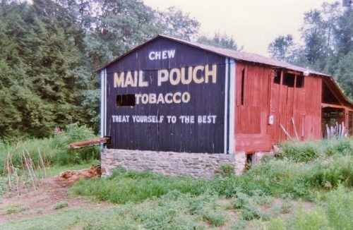
Photo 1
Sides Painted
2
Color
Black
Structure
Barn
Unique Characteristics
None
Still Standing
Yes
Credits

Photos 1-3 by Larry Zinn (July 1987 - contributed by Butch Moon).

Photos 4 & 5 by Larry Zinn (Feb. 1988 - contributed by Butch Moon).

Photo 6 by unknown.

Photo 7 by Elmer Napier (1999).

Photos 8, 9 & 15 by Gyla Schnauffer (June 2000).

Photos 10 by Steven Rotsch (2004).

Photo 11 Bing Map's bird's eye view.

Photo 12 by Debbie Sturm Moore Living (Sept. 26, 2014).

Photos 13 & 17 Google street views (July 2023).

Photos 14 & 18 by Bill Eichelberger (Oct. 16, 2023).

Photo 16 by Barbara Warnecke (ca. 2010).

Photo 19 Google satellite image.
Other Information

Photos 1-14 are views of the north end of the barn.

Photos 15-18 are views of the south end of the barn.
Where to find it

Along the east side of N. Mountaineer Hwy (WV-92) north of US-50 by about 9.0 miles. The barn is on the right side of the highway headed north. Two ends. Black backgrounds. South end sign covered by a barn extension and only the word 'CHEW' is visible from the highway.
Address
9310 N Mountaineer Hwy (WV-92)
City
Newburg
State
WV
Zipcode
26410
Country
USA
Latitude
N 39° 26.94'
Longitude
W -79° 48.89'
lat
39.44899748
lng
-79.81486498
  • Photo 2
  • Photo 3
  • Photo 4
  • Photo 5
  • Photo 6
  • Photo 7
  • Photo 8
  • Photo 9
  • Photo 10
  • Photo 11
  • Photo 12
  • Photo 13
  • Photo 14
  • Photo 15
  • Photo 16
  • Photo 17
  • Photo 18
  • Photo 19