MPB 35-59-07

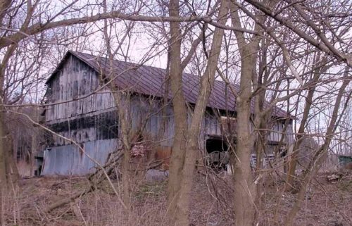
Photo 1
Sides Painted
1
Color
Black
Structure
Barn
Unique Characteristics
None
Still Standing
Yes, Greatly faded
Credits

Photos 1 & 2 by Rick Campbell (Feb. 2006).

Photo 3 by unknown ODOT # 3776-2-11 (Dec. 20, 1967) courtesy of Ohio Dept. of Transportation

Photo 4 by unknown ODOT # 3776-2-9 (Dec. 20, 1969) courtesly of Ohio Dept. of Transportation

Photo 5 Google street view (Oct. 2008).

Photo 6 Google street view (Nov. 2021).

Photo 7 by unknown ODOT # 3776-1-7 (Dec. 20, 1967) courtesy of Ohio Dept. of Transportation

Photo 8 Google satellite image.
Other Information

MPB 35-59-07 is east of MPB 35-59-06 by approximately 0.2 mile. In Photo 7 MPB 35-59-07 is circled in yellow. West of the barn MPB 35-59-06 is circled in red.

Photo 4 is a view of the east end of the barn to confirm that there was no Mail Pouch sign on that end.

Photo 8 (Google satellite imgae) the red pin is centered on the roof of MPB 35-59-07. The red pin was used to determine the address and the coordinates.
Where to find it

Along the north side of US-42 east of Main St. (OH-61), in Mt. Gilead, by 2.9 miles. The barn is on the left side of the highway headed east from Mt. Gilead. . The Mail Pouch sign faces west. One end. Black Background. Greatly faded.
Address
5996 US-42
City
Mt Gilead
State
OH
Zipcode
43338
Country
USA
Latitude
N 40° 33.57'
Longitude
W -82° 46.53'
lat
40.55945603
lng
-82.77558564
  • Photo 2
  • Photo 3
  • Photo 4
  • Photo 5
  • Photo 6
  • Photo 7
  • Photo 8