MPB 35-12-02

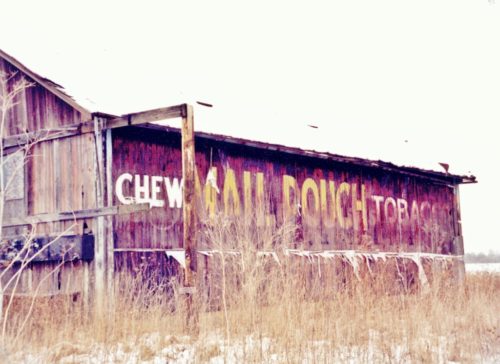
Photo 1
Sides Painted
1
Color
Black
Structure
Barn
Unique Characteristics
None
Still Standing
No
Credits

Photos 1 & 2 by Lonnie Schnauffer (Jan. 2003). 

Photo 3 by unknown ODOT # 6064-30-326 (May 5, 1966) courtesy of Ohio Dept. of Transportation

Photos 4 & 5 by Laura Purcell. 

Photo 6 Bing Map's bird's eye view.

Photo 7 Google street view (Oct. 2011).

Photo 8 Google street view (July 2019).
Other Information

Laura Purcell reported to Ryan Eash that this barn is partially collapsed as of April 2019.

Photos 7 & 8 are Google street views both from about the same location the Photo 8 (July 2019) showing that the barn was gone by that date.
Where to find it

*GONE* (razed and removed - it was in the process of falling down) Co. Hwy. 333 (Dayton-Springfield Rd.) east of I-675 by about 0.25 mile. Almost directly across from where Black Lane intersects into Co. Hwy. 333 from the south. The barn is on the left side of the highway headed east from I-675. The MP sign faces east. One side. Black background.
Address
8860 Dayton Springfield Rd (Co. Hwy-333)
City
Fairborn
State
OH
Zipcode
45325
Country
USA
Latitude
N 39° 50.88'
Longitude
W -83° 59.24'
lat
39.84798613
lng
-83.98733934
  • Photo 2
  • Photo 3
  • Photo 4
  • Photo 5
  • Photo 6
  • Photo 7
  • Photo 8