Other Information
Photos 1 & 2 are enlarged inset views from Photo 3.
Photo 4 is an enlarged inset view from Photo 5.
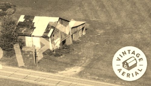
This is a very old barn Mail Pouch ad. In Photo 4, which is a 1976 view it appears that the old Mail Pouch sign is just beginning to bleed through. This sign was probably originally painted in the early 1960's or even the 1950's. Note in Photo 6 that the barn was existing in Sept. 1939. The style of the sign includes an element which was typically used in the earlier Mail Pouch advertising and that is the Mail Pouch visible in Photo 2. A detail of the Mail Pouch is provided in Photo 10 which is from a Mail Pouch sign in Ford City, PA.
MPS 38-03-08Note, also, in Photo 2 the word 'CHEW' at the top of the sign.
The Penn Pilot program was used to help locate where this barn was located. In searching historic aerial imaging the buildings on the site
Photos 3 & 5) were all razed and the site cleared prior to 2004.
In the Penn Pilot photos 6-8 the Mail Pouch barn is hi-lighted in yellow.
Once the barn was located the distance measurement tool in the Historic Aerials' webiste was used to obtain the decimal coordinates centered on the barn. These coordinates were input to the Google maps program and the red pin on Photo 9 is the exact location of where the Mail Pouch barn once stood. The pin was used to determine the address and complete the location information.
Where to find it *GONE* (razed and removed) Along the northeast side of US-322 southeast of White St., in Brookville, by 3.1 miles. The barn was on the left side of the highway headed southeast from Brookville. The Mil Pouh sign faced southeast. One side. Black background.


