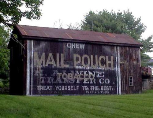
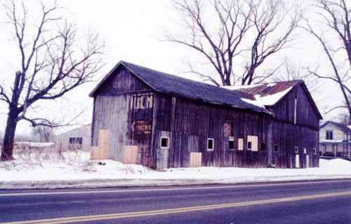
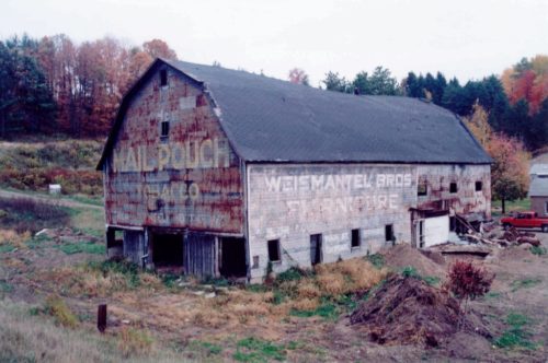
NY Rt. 242 & Farm Market Rd. intersection, in Napoli, southwest of the Erie St. (NY Rt. 353)/Rock City St. (NY Rt. 242) intersection, in Little Valley, by about 6.2 miles. The barn is on the left side of the highway headed southwest, just past Farm Market Rd. It is on a hill on the left, behind trees and very difficult to see from the road. The MP sign faces southwest. One end. Black. Greatly faded.
*GONE* NY Rt. 242 northeast of NY Rt. 394, east of East Randolph, by about 2.8 miles. The barn was on the right side of the highway headed northeast just before the Marley Hill Rd. intersection. The barn was on a hill behind a house and trees and very difficult to see from the highway. It was best viewed from Marley Hill Rd. The MP side faced north. The MP end faced east. Original Black backgrounds.
*GONE (painted over)* US Rt. 62 west of the US Rt. 62 'T' junction with Conewango Rd., in Conewango, by about 1.0 mile. The barn is on the left side of the highway headed west. The MP sign faces east. One end. Originally Black background.
*GONE* NY Rt. 353 southeast of US Rt. 62, in Dayton, by about 6.6 miles. The barn was on the left side of the highway headed southeast. Two ends. Black.
US Rt. 219 (Central Ave.) north of Wildwood Ave. (NY Rt. 417), in Salamanca, by about 1.6 miles. The barn is on the left side of the highway headed north. Two ends. Black.
*GONE* NY Rt. 16 south of NY Rt. 39 (Main St./W. Yorkshire Rd.), in Yorkshire, by about 3.5 miles. The barn was on the left side of the highway headed south. Two ends. Black.
NY Rt. 417 (Portville-Ceres Rd.) southeast of Brooklyn St. (NY Rt. 305), in Portville, by about 1.6 miles. The barn is on the left side of the highway headed southeast. Two ends. Black.
*GONE (razed and removed)* OLD US Rt. 219 north of North St., in Limestone, by about 0.7 mile. The barn is on the right side of the highway headed north. The MP sign faces south. One end. Black.
US Rt. 62 south of RT. 6 (Cherry Creek Hill Rd. ) intersection, in Leon, by 0.3 miles. The barn is on the left side of the highway headed southwest. The MP sign faces Northeast. One end. Original Black backgound. Painted over. Bleeding through. Greatly faded.
*GONE* NY Rt. 417 at Vandalia. The barn was on the north side of the highway. Two ends. Black background.
*GONE (razed and removed)* US Rt. 62 south of the US Rt. 62/NY Rt. 83 (Maple St.) intersection, in Conewango Valley by 1.2 miles. The barn was on the left side of the highway headed south. The Mail Pouch sign faced north. Black background.
NY Rt. 430 (W. Main St.) west of NY Rt. 99 (Kipp St./Hart St.), in Sherman, by about 1.7 miles. The barn is on the left side of the highway headed west. The MP sign faces east. One end. Black.
*GONE (painted over)* US Rt. 20 (E. Main St./Main Rd.) northeast of NY Rt. 394 (Portage Rd.), in Westfield, by about 3.1 miles. The barn is on the right side of the highway headed northeast. The MP sign faced northwest. One end. Original Black background.
*GONE* NY Rt. 60 north of Gerry by about 0.5 mile. The barn was on the left side of the highway headed north. The MP sign faced north. One end. Black.
*GONE (painted over)* US Rt. 62 (Main St.), west of the Pearl St. intersection, in Frewsburg, by 0.3 mile. The barn is on the left side of the highway headed west from Frewsburg. The MP sign faced west. One end. Black.
*GONE* (faded away) US-20 (W. Main Rd./Main St./Main Rd.) northeast of the Pennsylvania state line by about 7.7 miles. Northeast of NY-76 (State St.), in Ripley, by about 4.6 miles. Just east of Rogerville Road. The barn is on the left side of the highway headed northeast. One end. Black background.
*GONE* (faded away) NY Rt. 60 north of the crossroads, in Gerry by 7.7 miles. The barn is on the right side of the highway headed north. The MP sign faces north. One end. Black.
Duell Rd. south of Hunns Lake Rd., in Bangall, by about 1.1 miles. From Hunns Lake Rd. head south on Bangall Armenia Rd. for about 0.1 mile and bear right onto Duell Rd. Follow Duell Rd. south about 1.0 mile to the barn on the left side of the road. The MP sign faces south. One side. Black. Greatly faded.
*GONE* NY Rt. 270 south of the Niagara Co. line. One end. Black.
*GONE* NY Rt. 240 near Springville. One end. Origina Black background.


