- [01] Adams Co, PA (2)
- [02] Allegheny Co, PA (32)
- [03] Armstrong Co, PA (13)
- [04] Beaver Co, PA (12)
- [05] Bedford Co, PA (18)
- [06] Berks Co, PA (10)
- [07] Blair Co, PA (4)
- [08] Bradford Co, PA (1)
- [10] Butler Co, PA (19)
- [11] Cambria Co, PA (16)
- [13] Carbon Co, PA (1)
- [14] Centre Co, PA (12)
- [16] Clarion Co, PA (13)
- [17] Clearfield Co, PA (11)
- [18] Clinton Co, PA (6)
- [20] Crawford Co, PA (15)
- [21] Cumberland Co, PA (5)
- [22] Dauphin Co, PA (8)
- [24] Elk Co, PA (2)
- [25] Erie Co, PA (11)
- [26] Fayette Co, PA (29)
- [27] Forest Co, PA (3)
- [28] Franklin Co, PA (4)
- [29] Fulton Co, PA (10)
- [30] Greene Co, PA (29)
- [31] Huntingdon Co, PA (10)
- [32] Indiana Co, PA (14)
- [33] Jefferson Co, PA (11)
- [34] Juniata Co, PA (5)
- [36] Lancaster Co, PA (6)
- [37] Lawrence Co, PA (12)
- [39] Lehigh Co, PA (7)
- [40] Luzerne Co, PA (1)
- [41] Lycoming Co, PA (1)
- [42] McKean Co, PA (8)
- [43] Mercer Co, PA (17)
- [44] Mifflin Co, PA (7)
- [45] Monroe Co, PA (5)
- [46] Montgomery Co, PA (1)
- [47] Montour Co, PA (0)
- [48] Northampton Co, PA (5)
- [49] Northumberland Co, PA (1)
- [50] Perry Co, PA (5)
- [51] Philadelphia Co, PA (1)
- [54] Schuylkill Co, PA (2)
- [56] Somerset Co, PA (22)
- [59] Tioga Co, PA (1)
- [61] Venango Co, PA (7)
- [62] Warren Co, PA (2)
- [63] Washington Co, PA (29)
- [64] Wayne Co, PA (2)
- [65] Westmoreland Co, PA (24)
- [67] York Co, PA (8)
State Rt. 4014 (Million Dollar Rd.) To access the barn site from US Rt. 22/US Rt. 322, head northeast on PA Rt. 147 (S. River Rd.) for about 3.7 miles to Million dollar Rd. Make right onto Million Dollar Rd. and travel 0.2 mile to the barn on the right side of the road. The MP sign faces north. One end. Black.
*GONE (razed and removed)* Along the south side of US-209 west of Oakdale Station Rd. intersection, in Loyalton, by about 0.4 mile. The barn was on the left side of the highway headed west. The Mail Pouch sign faced east. One end. Black background.
*GONE* (razed and removed) Along the south side of W. Market St. west of Water St. intersection, in Williamstown, by 0.7 mile. The barn was on the left side Of Market St. headed west out of Williamstown. The Mail Pouch sign faced north. One end. Black background.
*GONE* (razed and removed) Along the southeast side of Jonestown Rd. northeast of the Bow Creek Rd. intersection, in Grantville, by 0.2 mile. The barn was on the right side of the road headed northeast from Bow Creek Rd. The Mail Pouch sign faced southwest. One end. Black background.
*GONE* PA-255 (Bennett's Valley Hwy.) southeast of PA-120 (State St.), in St. Mary's, by about 8.1 miles. The barn was on the right side of the highway headed southeast from St. Marys. The Mail Pouch sign faced southeast. One end. Black background.
US Rt. 6 (GAR Hwy./Roosevelt Hwy.) northeast of PA Rt. 8 (N. Main St.), in Union City, by about 1.6 miles. The barn is on the left side of the highway headed northeast. The MP sign faces northeast. One end. Brown.
*GONE* (razed and removed) Along the west side of Old rte-99 north of Oliver Rd intersection, in McLane, by about 1.4 miles. To access the barn site; head north on PA-99 (Edinboro Rd.) from the Oliver Rd. intersection about 0.2 mile to the Old rte-99 intersection. Bear left onto Old rte-99 and travel about 1.2 miles to the old barn site. The foundation is visible on the left side of the highway headed north. The Mail Pouch sign faced north. One end. Black background.
*GONE (razed and removed)* US-6 (Meadville Rd.) southwest of intersection with PA-8, in Union City, by 0.7 mile. The barn was on the right side of the highway headed southwest. The Mail Pouch sign faced northeast. One side. Black background.
*GONE* US-6N, 0.5 miles west of I-79. The barn was on the right side of the highway headed west. The Mail Pouch sign faced east. One end. Black background.
Along the north side of US-20 (W. Ridge Rd.), in Erie, southwest of Asbury Rd. by about 0.2 mile. The barn is on the right side of the highway headed southwest. It is behind a house and a grove of trees and is very difficult to see from the highway. The Mail Pouch sign faces northeast. One end. Black background.
*GONE (razed and removed)* Old rte 19N. north of the intersection with US-19 by 0.3 mile. The barn was on the left side of the highway headed north. The Mail Pouch sign faced south. One side. Black background.
*GONE* (painted over) Along the southeast side of E. Main St, northeast of intersection with PA-215, in East Springfield, by 0.7 mile. The barn is on the right side of the street headed northeast. The Mail Pouch sign faced southwest. One end. Black background.
*GONE* (faded away) Along the west side of Reichert Rd. northeast of PA-99 intersection, in McKean by 1.4 miles. (N. Main St. becomes Reichert Rd.) The barn is on the left side of the road headed northeast. The Mail Pouch sign faces southeast. One end. Black background.
Old Rt. 21 Rd. (T-440) west of US-119 by about 4.6 miles. The barn is on the left side of old rt 21 Rd headed east. The barn is visible from McClellandtown Rd (PA-21). One end Mail Pouch sign faces west. One side Mail Pouch sign faces north. Black backgrounds.
*GONE* (fallen. some rubble remains) US-40 (National Pike/W. Main St.) northwest of US-119, near Uniontown, by about 1.7 miles. The barn is on the left side of the highway headed northwest. The Mail Pouch sign faced northwest. One end. Black background.
Curfew Rd., in Perryopolis. To access the barn site; head south on PA-51 (Pittsburgh Rd.) about 0.7 mile from the intersection with PA-201 (Fayette City Rd.), to Curfew Rd. Make a left onto Curfew Rd and go 0.1 mile to the barn on the left side of the road. The Mail Pouch sign faces southwest. One end. Black background.
*GONE (covered up)* On Hickory Lane. Take PA Rt. 201 (Vanderbilt Road) west from US Rt. 119 approximately 1.6 miles to Adelaide Road. Make right onto Adelaide Road and go approximately 500 feet to Hickory Lane. Make right onto Hickory Lane. Barn immediately on right. Originally black, but has been painted over red and sign is bleeding through once again. One end and one side.
Dunbar Road (Sr1053/Woodvale St.) southeast of US-119 (University Dr.) by about 0.3 mile. The barn is on the left side of the road headed southeast. Two ends and one side. Black backgrounds.
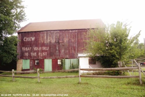
US-40 (National Pike) northwest of US-119 by about 5.5 miles. Just south of Hatfield road by 0.2 mile. The barn is on the left side of the highway headed northwest. The Mail Pouch sign faces southeast. One side. Original Black background. Greatly faded.
*GONE (fallen)* PA Rt. 201 (Vanderbilt Rd.) southeast of PA Rt 819 (Dawson Rd.) intersection, in Vanderbilt. The barn is on the left side of the highway headed southeast. The MP sign faced southwest. One end. Original black background.
