Other Information
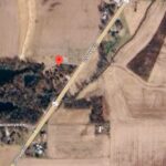
The mail Pouch barn and other buildings in the site configuration (Photo 2) are all clearly visible in Historic Aerials' imagery (1983). The distance measurement tool was used to obtain the decimal coordinates of the barn. The coordinates were input to the Google map program and the red pin on Photo 4 is the location where the barn once stood.
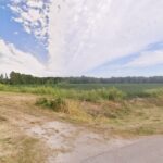
All the building sin Photo 2 have now been razed and removed and the site cleared and now used for agriculture. Two Google street views (Nov. 2008, and Oct. 2014) faintly show the house in amongst the trees.
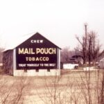
Photo 1 was featured in an article in the August 1982 issue of Smithsonian Magazine, entitled 'His paintings are national treasures - sort of, anyway', by Jack Fincher. This photograph was on page 113 of the magazine.
Where to find it *GONE* (razed and removed) Along the northwest side of US-421 southwest of Perry St./US-50 intersection, in Versailles. The barn was on the right side of US-421 headed southwest away from Versailles. The Mail Pouch sign faced south. One end. Black background.


