MPB 14-31-06

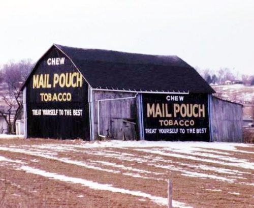
Photo 1
Sides Painted
2
Color
Black
Structure
Barn
Unique Characteristics
None
Still Standing
No
Credits

Photos 1 - 4 by Tom Plimpton (1984).

photo 5 by unknown VA # 44-EHA-30 (1976) courtesy of Vintage Aerial

Photo 6 by unknown VA # 28-DHA-5 (1979) courtesy of Vintage Aerial

Photo 7 by unknown VA # 54-PHR-30 (1985) courtesy of Vintage Aerial

Photos 8-10 by Chris Stegner.

Photo 11 by unknown (Warrick Family Collection).

Photo 12 Google street view (Oct. 2008).

Photo 13 US Geological Survey satellite image (Mar. 23, 1998).

Photo 14 Indianamap Framework Data image (Feb. 28, 2005).

Photo 15 Google satellite image.
Other Information

The house on the site (Photos 5-7) is still existing as of Oct. 2008 (Photo 12). The barn has long been gone, probably fallen since there is some signs of rubble in Photo 14 (area circled in yellow); and, in Photo 15 the area where the barn once stood is defined by trees and brush growth, indicating there is enough rubble remaining that the area cn not be used for farming. This is noted by the red pin and this was used to determine the adddress and coordinates. In satelitte images (Photos 13 & 14) the house which is still existing is circled in red and other structures shown on Photos 5-7 are circled in lime for coordination.
Where to find it

*GONE* (fallen - some rubble remains) Along the southwest side of IN-62 northwest of the IN-135 intersection, in Corydon, by 2.2 miles. The barn was on the left side of the highway headed northwest away from Corydon. The Mail Pouch side faced north. The Mail Pouch end faced east. Black Backgrounds.
Address
2399 Fey Ln NW
City
Coryton
State
IN
Zipcode
47112
Country
USA
Latitude
N 38° 14.1014'
Longitude
W -86° 10.6384'
lat
38.235023
lng
-86.177307
  • Photo 2
  • Photo 3
  • Photo 4
  • Photo 5
  • Photo 6
  • Photo 7
  • Photo 8
  • Photo 9
  • Photo 10
  • Photo 11
  • Photo 12
  • Photo 13
  • Photo 14
  • Photo 15